See EarlySubway Plans section for more diagrams
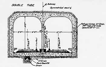
Significant elements of the partially completedRapidTransit Loop still exist, including the largest tunnel, which runs 2.1miles under Central Parkway from downtown until it emerges just northofthe WesternHills Viaduct. The Central Parkway subway is constructedentirelyof reinforced concrete, with parallel tubes measuring about 15ft. highand 13ft. wide. Station platforms are 48" high and about 300ft.long. Wooden runners, on which the rails were to be attached, are still inplacethroughout much of the tunnel, and are super-elevated (banked) atcurves. As therewere no locks along this section of the canal, there are no significantgrades. A drainage system has kept the tubes for the most part free ofstanding water. The tunnel was built in four phases by differentcompanies,and slight differences in the concrete used can be seen, but thedimensionsand general look are consistent. A sharp 90 degree curve exists at thePlum St. intersection, but otherwise curves are rather mild, built on aminimum 1,000ft. radius, so that a speed of 45mph could be maintained.Portals exist at the north end, but the tunnel's south terminus isunderneaththe intersection of Central Parkway & Walnut, and so there are nosouthportals. The 80 year old tunnel is inspected monthly and is in"satisfactoryto good" condition, with no major cracks or water leakage. The tunnelwasgiven an extensive inspection and repair work in the 1980's and willnotrequire any more major work for at least ten years.
See EarlySubway Plans section for more diagrams
As mentioned before, this tunnel has stations atRaceSt., Liberty St., Linn St. (Mohawk's Corner), and Brighton's Corner.Thelatter three stations have simple side platform layouts, measuringabout300ft. long. The Brighton's Corner platforms are about 15ft. deep, witha row of concrete pillars about 4ft. from the edge of the platform (abitfurther back than the I-beam pillars common on the New York subway,whichblock train doors). Due to the wider parkway width further south,the Liberty St. platforms are about 20ft. deep, with 2 rows of pillars,and are accessed via hallways about 30ft. long. The Linn St.stationis sealed off at the platform edges with cinder blocks, and it isunclearas to whether platforms were actually built here, or if the cinderblockswere meant to be "punched out" if a station were ever constructedhere.
Cincinnati's tunnel is shallow, located immediatelybelowstreet level. No stations featured mazzanines, so inboundand outbound trains were to have been reached by staircases on oppositesides of the above street, like many subway lines elsewhere that runimmediatelybelow street level. Bathrooms measuring about 15'X15' werelocatedalong the sidewalk staircase concourses of both Liberty St. stationplatformsand the inbound Brighton's Corner station platform. Outboundridersat Brighton's Corner had to hold it.
The downtown Race St. station is significantlylargerthan the others, with a complicated three track layout. Here thesubway roofis supported by rows of columns similar to those of an undergroundparkinggarage. Once again there is no mezzanine, however the station isentered viastaircasesin the parkway's landscaped median to a large symmetrical islandplatform. Inbound and outbound trains served opposite sides of the platform, withunusual center stub tracks for interurban terminal service. Aninterurbantrain approaching the station would have switched from the inboundtrack to thecenterinterurban track, and after dropping off and picking up new passengers,reversed direction and switched onto the outbound track. Identical,mirrored facilities were built on both the east and west ends of thestationfor interurbans arriving from either direction. Additionally,provisions were made for passing sidings to the north and south of thestation. Short stubs for these bypasses were built to the eastunderthe Vine St. intersection and to the west under the Elm St.intersection. Platforms were possibly planned for theseadditional two tracks, but I have not been able to find any informationon them.
The most complicated trackwork seen in the subwayexistseast of the station, between Vine St. and Main St. This two blockarea includes provisions for the above mentioned passing sidings, eastinterurbanstub switches, southward turn to the Walnut St. tunnel stubs, and awye which extends towards Main St. The wye might have beena provision for a specific east side interurban line which operatedtrainswith cabs on only one end. Another wye exists on the west side ofthe station, near the Plum St. turn, serving the inboundtube. The end of this wye extends into the block bordered by Elmand Plum and almost as far south as Court St.
The Race St. Station is also unusual in that itslocalplatforms are over twice as long as those on any other station, meaningeach could have served two trains at one time, or more likely, trainsforspecific routings were to have stopped at either the east or west endofthe platforms. That means that together with the two interurbanstubsthere were 6 different places trains could load and unload. Largeplatforms such as these are useful for handling the crowds that canquickly accumulate on subway platforms during service delays.
The Race St. Station had no bathrooms, however itdoeshave a staircase in the center of the platform that descends toconcoursesthat were to connect with sidewalk entrances and to buildings liningtheparkway above. The station also originally had four large circularventilationgrates in the ceiling which dually served as skylights. These wereremovedwhen the parkway above was widened in the 1950's, and now there isalmost noventilation in this section of the tunnel. Needless to say, haditbeen put into operation, Cincinnati's Race St. Station would havecertainlyranked among the most eccentric subway stations in the United States,something akin to Park St. Station in Boston.
Ventilation
Three kinds of vents were built along the length of theCentral Parkway Subway. Between the end of the subway at WalnutSt.and the Liberty St. Station, large square vents were spaced regularlyinthe Parkway median, centered over the tubes below. These ventswereremoved in the 1950's. Between the Brighton's Corner Station andthe Liberty St. Station, irregularly spaced vents on either side of theParkway connected to the tunnels below. Metal ladders were builtinto the concrete walls of the subway tubes at each vent, howeveralmostall of these ladders have rusted through today. North of theWesternHills Viaduct and until the portals, the subway acts as a terrace andisactually above ground level. Here vents were built directly intothe subway's western wall and have been broken into many times byvandals. Subsequently a number of these vents have been filled in with concrete,however the steel bars remain at a few.
Suburban Tunnels
Most that have heard about "The Subway" know only ofthe Central Parkway tunnel. Almost a dozen shorter ones were plannedalongthe 16 mile route, but only three were built. None of these shortertunnelshad underground stations.
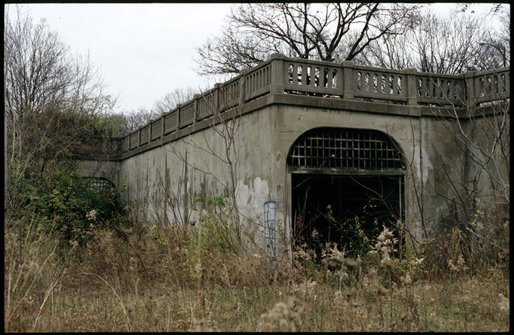
After emerging from the two mile long CentralParkway subway,the line headed above ground 1/4 mile to the Marshall Ave. station, andthen another 1/4 mile before entering the second tunnel. This tunnelwasoriginally a Hopple St. underpass, and is about 400ft. long. Thesouthernportals are of the same style and dimensions of the Central Parkwaysubway'snorthern portals, except staggered in the opposite direction. There areno longer any northern portals, as the tunnel stops abruptly under theintersection of Hopple St. & Martin Luther King Drive (formerlyDixmyth Avenue).Prior to I-75 construction, these streets did not intersect, and so thenorthern portals were sealed with cinder blocks during the alignmentproject.In earlier subway plans, there was to be no Marshall St. station, andinsteadthere was to be an underground station at Hopple St. The tunnel itselfwas to be located a few hundred feet west, in the exact path of I-75,andwas to run almost as far north as Ludlow Ave.
There were also two more short tunnels built in theNorwoodarea. Here the Rapid Transit Loop diverged from the canal route and onpurchased right-of-way where the NorwoodLateral Expressway is today. Thesubwaytraveled on a different route than the Lateral between the Reading Rd.interchange and the Section Rd. overpass, and this 1/4 stretch includeda 900ft. tunnel under Section Rd. The southern portal of thistunnelwas destroyed in 1971 during expressway construction and the rest ofthetunnel was filled in.
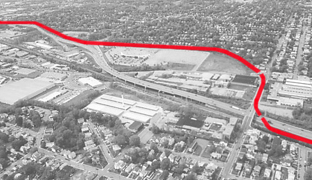
This graphic shows the subway route with relation to the expresswayand the location
of the short tunnel.
From there the Rapid Transit Loop headed east 3/4milebefore reaching its 4th tunnel, which measures 950ft. in length. Thistunnel was recently filled in in early 2004. It ran directlyunder the Zumbiel Packaging warehouse, whichwas built after the tunnel was constructed. The west portals were flushwith the warehouse's loading dock, and were visible from either HarrisAve.or the Wesley Ave. overpass. East of the warehouse, a spur from theB&0passed on the surface over the tunnel, as did Forest Ave. This spur wasformerly an interurban line, and was to feed into, or at least transferwith the Rapid Transit Loop at this point. The Forest Ave. station wasoriginally supposed to be half in this tunnel and half in the open,howeverno construction was started on it. The east portal is located about40ft.east of the street, in Norwood's Waterworks Park, behind a baseballfieldbackstop.
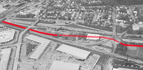
This graphic shows the location of the second of the two short Norwoodtunnels.
The east portal of this tunnel marks the easternmostextentto which the Rapid Transit Loop was completed. It was estimated thatthetransit line would have saved travelers from this point 15-20 minutesversusexisting street car lines.
The Cousin of Boston's Red Line
The southern half of Boston's Cambridge-Dorchestersubwayopened in 1925, the same year that the Cincinnati project wasabandoned. The Cincinnati Rapid Transit Loop was designed to operate equipmentidenticalto Boston's, and similarities in construction materials and styles canbe seen. The Downtown Crossing and South Station stations indowntownBoston both have central support columns identical to those inCincinnati'sBrighton and Liberty St. stations. The Broadway station hasan island platform with columns similar to Cincinnati's Race St.station. Between South Station and Broadway a tunnel leading to the line's oldserviceyard features the same concrete construction and portal style asCincinnati'svarious tunnel portals.
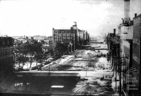
Central Parkway
Central Parkway was built above the subway through aseparate funding source and opened in 1928. The street today isfairlyunusual for several reasons. First, Central Parkway parallelsCentralAve. for much of its length, leading to much confusion and countlesslostdrivers over the last 70 years. Moreover, neither "central"streetruns through the center of the city. Additionally, the Parkwaymakesa harsh 90 degree turn at Plum St., meaning it is both a north/southandeast/west road in the street grid, and that one must turn in order tostayon it. This situation has also led to much confusion, whichcould have been easily avoided by keeping the native "Canal St." moniker forthe east/westportion. Also, since few buildings were built facing the canalnorthof the Plum St. turn, numerous surviving canal era buildings face awayfrom the Parkway, most conspicuous of which is Music Hall (1878). There is also a series of old row houses whose plainbacksidesface the Parkway near the Brighton's Corner Station. Manyproposals have been made to rename Central Parkway -- proposals forGeneral MacArthur Parkway, John F. Kennedy Parkway, and Martin LutherKing, Jr. Parkway have all failed.
Central Parkway construction in 1928, at the Plum St. turn lookingeast.
Since the backs of most old buildings faced theParkway,many were demolished and replaced in the mid-1900's. Therefore north of Liberty St. the Parkway is an oasis ofvintagesuburban roadside architecture in the middle of a densely built 19thcentury rowhouse neighborhood. The downtown stretch of the Parkwaybetween the Plum St. turn and Broadway has largely stagnated for thelast40 years but has recently shown signs of life.
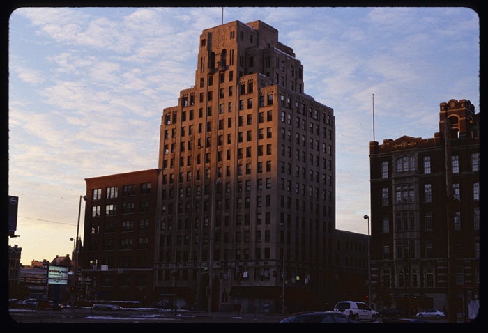
The American Building at Central Parkway & Walnut.
[January 2004 Jake Mecklenborg]
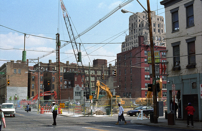
Early construction view from 12th & Vine of new Kroger Garage &Condos.
[April 2004 Jake Mecklenborg]
The City of Cincinnati broke ground on a largeparkinggarage and condominium building in April of 2004. This was thefirstlarge building to be constructed along the downtown section ofCentralParkway since 1958. The building occupies the blockbetween12th St., Vine St., and Jackson St. and includes over 1,000 parkingspaces and thirty condominiums. Anotherlarge project, construction of a new campus for the School of Creative and Performing Arts,broke ground in fall of 2007 and should open in 2009. SPCA will occupy all of a full-size 400x400 block thatsat for many years as a parking lot.
ConstructionPhotos
PortalPhotos
BrightonStation Photos
LinnSt. Station Photos
LibertySt. Station Photos
RaceSt. Station Photos
HoppleSt. Tunnel
NorwoodTunnels
1950'sPhoto Tour
EarlySubway Plans and Diagrams
SubwayMaps