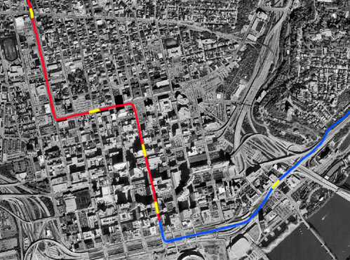
Fundamentally, the "subway" would consist of a two-track, 16 mile "Rapid Transit Loop". In the report, all suburban track and approaches to downtown were referred to as the "Canal St. Beltline". The path of the beltline, in a clockwise direction, would progress north from downtown in the canal bed as a subway roughly four miles to a point just north of Bates Ave. (approximately where the I-74 westbound entrance ramp is located today). Underground stations would be located at Race St., Liberty, Brighton, and Hopple. The line would continue along the path of the canal to St. Bernard, mostly on the surface, before deflecting from it three miles later, turning east toward Norwood. Stations would be located at Crawford St. in Northside, Mitchell Ave., and Carthage Ave. (today's Vine St.) in St. Bernard. In Norwood, the line would mostly parallel the B&O mainline, with surface stations at Paddock Rd., Montgomery Rd., and Forest Ave. Just east of Forest Ave., the line would turn south with a station near today's I-71 Smith-Edwards interchange. The line would then follow the present southwest path of I-71 to Dana Ave., then run due south through Owl's Nest Park and O'Bryonville to the bluff above the Ohio River. Stations would be located at Dana Ave. and Madison Rd. at Torrence Parkway in the O'Bryonville buisness district. The line would then head west, high above the Ohio River, paralleling Columbia Parkway on a 6,100ft. concrete terrace before tunneling through Mt. Adams, entering near the Eden Park Reservoir. Connecting back with the canal subway under today's Central Parkway, a continuous tunnel would be formed between Eden Park and a point north of Hopple St. measuring roughly six miles. All in the canal bed would be built via the cut-and-cover method, whereas the tunnel through Mt. Adams would be bored. Another short bored tunnel would also be dug through the hill above the intersection of Columbia and Torrence parkways. Several minor cut-and-cover tunnels, all of lengths shorter than a quarter mile, were to dot the beltline's suburban routing.
Excerpted directly from the report:
The total length of the line is
15.56 miles, of which 6.50 miles are in subway, 0.63 miles in [bored]
tunnels and 8.43 miles in the open. Included in the open are twenty
bridges with a total length of 2,206ft. and 6,100ft. concrete trestle along
the Ohio River Bluff.
Three alternate downtown routings were proposed. Schemes II, III, and IV augmented the Canal St. Beltline (which was designated as "Scheme I"), making the report somewhat confusing at first read. Blue Text is excerpted directly from the report.
SCHEME II

Subway in RED, stations
in YELLOW
Scheme II supplements Scheme I and is a loop line that encloses a large part of the downtown district of the City. It leaves the "Canal St. Belt Line" at the intersection of Canal and Plum St. and runs south in Plum St. to 5th St., east in 5th St. to Main St., and north in Main St. connecting with the Belt Line in Canal St. This loop is a two-track subway throughout, 1.31 miles in length, making with the Belt Line a total of 16.87 miles. There are three station located upon it. One in Plum St. with entrances and exits at both 7th and 8th streets. One in Fountain Square with entrances and exits at both Vine and Walnut Streets, and one in Main St. with entrances and exits at both 7th and 8th streets. These entrances and exits are all from the sidewalks.
The cost of the Loop Railway per lineal foot is considerably more than the cost of the Subway in the Canal, largely due to the presence in the streets of sewers, electric ducts, water and gas pipes which will have to be supported during the construction of the subway, or removed to a new location, the extra precautions required because of the nearness of large buildings, the removing and restoring of the pavements and the delays in construction due to business and traffic in the streets.
It is assumed the work will be done in an open trench not more than 400ft. of continuous street, including only one cross street, being open at one time.
Scheme I and Scheme II supplement each other and
together make an ideal transit plan. Scheme I or the "Canal Street
Belt Line" surrounds a residential district. Scheme II or the "Loop
Line" encloses a large part of the business district, the prosperity and
permanence of which largely depends upon the conveying of the residents
of the City to and from their business houses in the shortest time and
with the least inconvenience."
SCHEME III
Subway in RED, stations
in YELLOW
Scheme III or the "Ninth St. Belt Line" includes Scheme I with the exception of that part east of Plum St. in Canal St. and under Mt. Adams to near the Eden Park Reservoir. For the part omitted, the following route has be substituted: from the intersection of Plum and Canal Streets south in Plum St. to 5th St., east in 5th St. to Walnut St., north in Walnut St. to 8th St., east in 9th St. and under Mt. Adams to connect with Scheme I near the Eden Park Reservoir.
The substituted part is a two-track subway or tunnel throughout. The total length of the scheme is 16.31 miles, which includes 7.07 miles of subway, 0.80 miles of tunnel and 8.44 miles in the open. Canal Station is omitted and three stations added as follows: one in Plum St. with entrances and exits at both 7th and 8th Streets, one on Fountain Square with entrances and exits at both Vine and Walnut Streets, and one in 9th St. with entrances and exits at both Main and Sycamore Streets. In this scheme it is assumed that all interurban baggage and express matter will be handled at the Plum St. Station.
The object of this scheme is to reduce the cost
of the combined Schemes I and II and retain the advantages of the stations
in the business district. A subway and station in Canal St. may be
added at any time traffic conditions require it.
SCHEME IV
Subway in RED, elevated
in BLUE, stations in YELLOW
Scheme IV, or the "Pearl St. Belt Line," includes Scheme I with the exception of that part east of Walnut St. in Canal St. and under Mt. Adams to near the Eden Park Reservoir. For the part omitted the following route has been substituted: from the intersection of Canal and Walnut Streets south in Walnut St. to Pearl St., then east in Pearl and Martin Streets and private property to connect with Scheme I near the Eden Park Reservoir.
The substituted part is a two-track subway in Walnut St. from Canal St. to 4th St. Between 4th and 3rd Streets, the tracks, on a rising grade, break through the ground and continue on a rising grade till they are on a steel elevated structure on 3rd St. The elevated structure is continued in Pearl and Martin Streets and over private property to connect with Scheme I near the Eden Park Reservoir. The total length of the scheme is 16.46 miles, which includes 6.40 miles of subway, 0.15 miles of tunnel, 1.44 miles of elevated structure and 8.47 miles in the open. The location of Canal Station is changed from between Vine and Race Streets to between Race and Elm Streets and three stations are added, one on Walnut St. with entrances and exits at both 8th and 9th Streets, one on Walnut St. with entrances at both Fountain Square and near 4th St., and one on Pearl St. at the approach to the L&N Bridge with entrances and exits at the Pennsylvania Railroad Station.
By use of an elevated structure in the substituted route in the place of a subway or tunnel, the cost of construction is considerably reduced. Although nine-tenths of a mile longer than Scheme I, the cost is about the same.*
In the downtown district the number and locations of the stations is Scheme IV offer almost as many advantages to those who would make use of the railway as do the combined stations of Schemes I and II and at a much less total cost. If at some future time, it were deemed necessary to place the tracks of the Kentucky surface lines that are in this City in a subway, the connection with the Cincinnati Rapid Transit Railway could not be so advantageously made under the plans of Scheme IV as under the plans of Schemes II and III.
Changing from a subway to an elevated structure on Walnut St. between 4th and 3rd Streets, makes it necessary to occupy a strip of the street 25ft. in width for practically the entire distance between those two streets. There will remain 20.5ft. on each side for street purposes. Allowing 8ft. for a sidewalk and 1ft. as a hubguard to protect the fence along the open incline track, there will remain 11.5ft. clear space for roadway which will make necessary a one-way street.
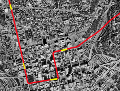
*In an effort to minimize confusion, elsewhere on the web page the Pearl St. el is called the "3rd St. el", because neither Pearl St. or Martin St. still exist. Pearl St. paralleled 3rd St. where the mainline trench of Fort Washington Way is today, and east of Broadway the el would have followed the route of the U.S. 50 3rd St. Viaduct to Mt. Adams.
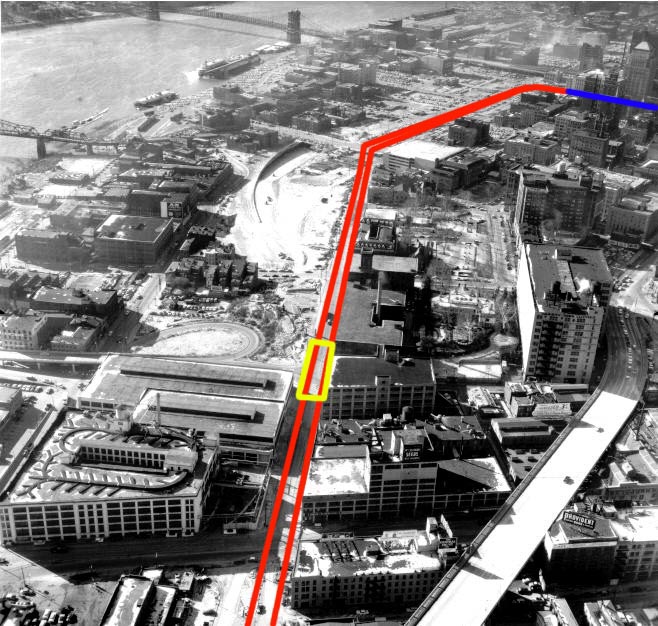
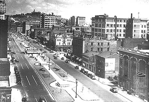
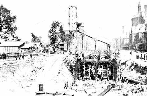
This 1950's photo shows Cincinnati's eastern riverfront during construction
of Ft. Washington Way.
Red shows the proposed path the Pearl St. Viaduct and its "L&N
Bridge" station is shown in yellow.
The never-built Walnut St. Tunnel is shown in blue.