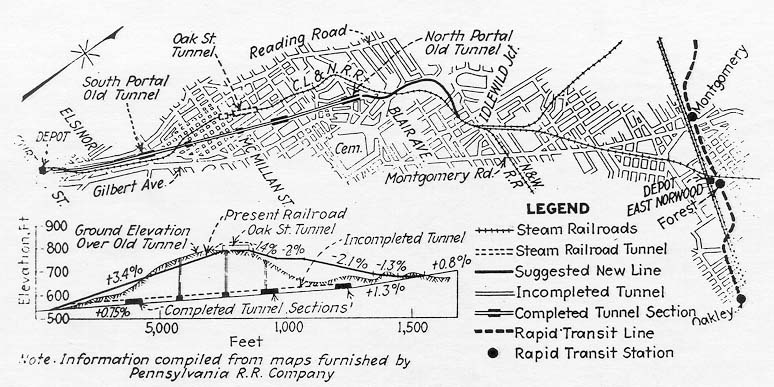
This diagram appeared in the Beeler Report, detailing possible substitutionof either the CL&N or Deer Creek Tunnels for the originally
planned eastern half of the Rapid Transit Loop.
Construction of the line began in 1920 and stopped in1925. Several major attempts were made to revive the project, butin that era no federal funding was available for local transportation projects. Ohio had already donated the canal right-of-way, and states did not typicallyfund local projects either. During the Depression, there was significantfederal funding for subway construction in Chicago, but none was allocatedto Cincinnati. After WWII, the nation's entire transportation shiftedto expressways, and with 90% federal funding for the Interstate HighwaySystem (and none for subway projects), Cincinnati used the graded RapidTransit Loop right-of-way as the local 10% contribution for constructionof first I-75 in the 1950's and then I-71 and the Norwood Lateral in the1970's. Therefore the $6,000,000 subway bond issue of 1916 eventuallypaid the local match for federally funded expressways along its route. The U.S. Government began funding subway projects in the 1970's and nowtypically provides 50%-75% funding for approved rail projects, includingCincinnati's proposed light rail network.
The Beeler Report
The Beeler Organization, a New York City consulting firm,produced a 150 page study in 1927 regarding city transit conditions andmade 10 recommendations on how to best complete the Rapid Transit Loopand operate it. They were:
1. Merge all street railway and bus systems. The subwaywas to be operated under this new consolidated agency.
2. Extend existing subway from its current terminus under Central Parkwaysouth under Walnut St. 6 blocks to a large station under Fountain Square.The Fountain Square station was to be the terminus of the line, as theoriginal eastern alignment of the loop and the 3rd St. elevated plans wereabandoned. The Fountain Square station was estimated to be the arrivaland departure point for 47% of all trips on the line.
3. Complete line from Forest Ave. to Madison Rd. in Oakley
4. Construct new street car line from Madisonville and Mariemont tonew Madison Rd. Station in Oakley
5. Abandon Ludlow Ave. station, and build new station on north endof the Ludlow Viaduct, at Knowlton's Corner in Northside. This requiredre-routing of the existing line with 2 new bridges over the Mill Creekand a short el in Northside, at a cost of $700,000.
6. Operate the following stations in the line: Fountain Square (new),Race St., Brighton's Corner, Knowlton's Corner (new), Vine St. (St. Bernard),Paddock Rd. (an overpass had already been constructed, but with no intentionof a station in this location), Montgomery Rd., Forest Ave., and MadisonRd. Abandon these stations: Liberty St., Linn St. (Mohawk's Corner),Marshall Ave., Ludlow Ave., and Clifton Ave.
7. Eliminate paper transfers
8. Adhere to service recommended in this report
9. Sign College Hill Interurban as tenant on Rapid Transit Line. CollegeHill trains to enter north of new Knowlton's Corner station, and run expressfrom this station to Fountain Square Station, where they would have dedicatedtracks and platforms separate from Rapid Transit Loop trains. The FountainSquare Station was to have had a mezzanine and underground connectionsto nearby buildings, including Dixie Terminal at 4th & Walnut.
10. Changes in street cars, bus schedules, and running time in generalin order to give patrons the advantage of full distribution facilitiesto and from the Rapid Transit Line and secure for the system a minimumof fare.
This diagram appeared in the Beeler Report, detailing possible substitutionof either the CL&N or Deer Creek Tunnels for the originally
planned eastern half of the Rapid Transit Loop.
The Beeler Report also investigated completion of theeastern section of the originally planned Rapid Transit Loop. Before WWIa subway was planned under Walnut St. from the canal south to 3rd St.,and then an el east above 3rd St. to the present day location of ColumbiaParkway (essentially the route of the present-day U.S. 50 3rdSt. Viaduct). This was deemed too expensive due to the low revenueexpected from the city's sparse eastern population, and instead a shorterroute was studied through Walnut Hills, then the city's most populous suburb.A subway under or el above Gilbert Ave. and Montgomery Rd. was prohibitivelyexpensive, therefore the purchase of an existing railroad was sought. Theacquisition of the nearby CL&N RR, which ran a busy mix of freight,passenger, and commuter trains, was not possible, nor was building an elover it. Additionally, the short single track OakSt. Tunnel along this line would have created a bottleneck in the system,which was unacceptable. Purchase of the nearby 9,000ft. DeerCreek Tunnel, which had stood incomplete and unused since 1855 wasalso impractical because its 200ft. depth promised extremely expensivestation construction costs. Neither the CL&N line or DeerCreek RR Tunnel came close enough to the most densely populated areas,and would offer no more than 5-10 minutes saved over street cars for mostriders. It is also unclear as to how the "loop" would have operated ineither of these scenarios, as it would not have formed a true loop. Two"spurs" would have existed, the first being the Walnut St. Tunnel and FountainSquare station, and the other the section between the Madison Rd. terminusand wherever the substituted eastern leg would have tied in.
In response to the Beeler Report and the $10,000,000 estimatefor completion, city council stalled and no new bonds were issued. TheDepression hit in 1929, and no new work was undertaken.
As the city and state started to fund major road improvements(paving, widening, viaducts, etc.) most of the interurban lines were drivenout of business by the automobile. Since the subway and Rapid TransitLoop was to primarily serve suburban commuters, its usefulness in the comingautomobile age was in question.
The Trolley Subway Proposal
The subway had been built for standard high platformsubway cars and interurbans, meaning the city's existing street cars couldnot serve stations without lowering the platforms, which would have beena considerable expense. But during the Depression in1936 another major study and effort was made towards making use of whathad been constructed of the Rapid Transit Loop, with the additional goalof removing all trolley tracks and traffic from downtown. This wasto have been accomplished via an elaborate downtown subway loop surroundingan 18-block area resembling Scheme II of the 1914 plan. The loopwould have run under 5th St. between Race & Main, Race and Main betweenCentral Parkway and 5th, and Central Parkway between Race & Main. Loopstations were to have been located at Fountain Square, 7th & Race,7th & Main, Court & Race (replacing the existing Race & CentralParkway Station), and Court & Main. Approach tunnels for the individualstreet car lines were to have been built, some with underground stationsjust for that line, located at 8th & Elm, 12th & Vine, and Reading& Pendleton. Street cars were to have entered the loop via flying crossoversand would have descended or ascended to the pair of main loop tracks onramps. Cars on specific routes would use either the outer or inner loopmain and would never use the opposite. Carried over from the Beeler Reportrecommendations, the College Hill interurban would have utilized the canalsubway and downtown street car loop. Needless to say, side-by-sideoperations by 3-rail interurbans and a half-dozen trolley lines wouldhave been extremely complex.
Although huge transit construction projects were undertakenduring the Depression years including the privately built Union Terminal(which at $41,000,000 cost 4X what was needed to complete the Rapid TransitLoop), the WesternHills Viaduct (built by the Union Terminal Company), the 5thSt. Viaduct (public funding) and Columbia Parkway (public funding),no money was secured for the downtown trolley loop or completion of theRapid Transit Loop and no further construction was undertaken. The2 mile Central Parkway subway tunnel and many of the suburban underpassesand overpasses were maintained, but the grading itself in many places becameovergrown by the 1950's. The above-ground stations were not maintained,and the Ludlow Ave. station deteriorated so severely that it collapsed. Today the only stretch of grading that can still be seen is a trench behindShowcase Cinemas in Norwood.
In the 1980's the subway was studied for transit use.Under the proposed scheme the abandoned West Side C&O branch was tofeed commuter trains into the subway just north of the Western Hills Viaduct.This plan would have required a new viaduct for the line across the MillCreek Valley, and stations along the line probably located at Quebec, Boudenoit,and Bridgetown Rd. At that time refurbishment of the 2 mile Central Parkwaysubway tunnel was estimated at $20 million. An extension down Walnut St.,with stations at 8th St., Fountain Square, and Riverfront Stadium was estimatedat $70 million. Considering how few neighborhoods could have been servedby this scheme, and the demographics, it is unlikely that the line couldhave attracted more than 20,000 riders per day. The decision against constructionof this line proved wise, as the West Side's population has remained steadyfor the past twenty years, and it is unlikely that the line alone wouldhave encouraged any significant commercial or residential development.
ConstructionPhotos
PortalPhotos
BrightonStation Photos
LinnSt. Station Photos
LibertySt. Station Photos
RaceSt. Station Photos
HoppleSt. Tunnel
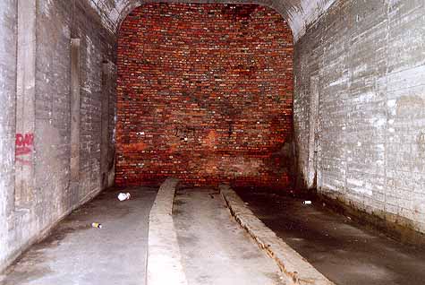
NorwoodTunnels
1950'sPhoto Tour
EarlySubway Plans and Diagrams
SubwayMaps