Cincinnati's Abandoned Subway
The book has much more information than this website, especially political discussion.
The book can be
purchased in paperback or digital form at Amazon.com.
Below is the article that has appeared on this website since about 2001:
Cincinnati's Abandoned Subway
Introduction
Abandoned tunnels are often the object of urban legend,
but Cincinnati is in fact the site of the country's largest abandoned
subway
tunnel. But "abandoned" is not quite the word, as construction
slowed
to a stop in the late 1920s before even half of the 16 mile line was
completed.
Seven miles between Cincinnati's central business district and the
industrial
suburb of Norwood were tunneled, bridged, or graded, but no track was
laid
and no subway cars were ordered. No passengers ever rode between
the six stations that were built.
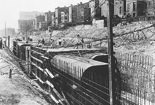
The incomplete Cincinnati line sat fallow through the Great Depression and WWII. Bridges, stations, and retaining walls along the surface stretches deteriorated to such an extent that a few items actually collapsed. Nearly everything above ground was bulldozed to make way for portions of I-75 and the Norwood Lateral in the 1950's and 1970's, respectively. The mute two mile tunnel that remains under Central Parkway is unknown to many Cincinnati natives, and what most who do know of it know consists largely of hearsay and speculation.
This website is the most comprehensive and most
accurate
source of information regarding the subway either on the web or in
print.
It is by far the most popular subject on www.cincinnati-transit.net,
and tens of thousands have visited it since its appearance in 1999.
Subway F.A.Q.
1. Where is the subway?
The main subway tunnel runs under Central Parkway for two miles,
between
Walnut St. and an anonymous spot north of the Western Hills
Viaduct.
Three underground stations were built and still exist at Race St.,
Liberty St., and
Brighton's Corner. An extension of this tunnel under Walnut St.
south
through downtown with a station at Fountain Square was planned but
never
built. Additionally, several miles of surface running line were
graded
and three of roughly a dozen planned above ground stations were
built.
Significant portions of today's I-75 and the Norwood Lateral follow the
path of the line. A stretch of I-71 near the Dana Ave.
interchange was built where the subway loop's eastern half was planned.
2. When was it constructed?
The main subway tunnel was built in four contracts between 1920 and 1923. A fifth subway contract paid for by the Central Parkway bond issue extended the subway in 1927 north from the Brighton Bridge to the portals still visible from I-75. This means the subway section under Central Parkway forming the north edge of downtown is seven years older than the portals.
3. Can the tunnel still be used?
Yes. It has been continuously maintained and will likely be
usable
for the next one hundred years, if not longer. The 2002 "Metro Moves"
sales tax would
have
funded a rail transit network that planned to use the tunnel, but it
was
defeated by a 2-1 public vote.
Section
1 Planning and construction
Section
2 Completion attempts
Section
3 The subway today
Section
4 Various proposals
Section
5 What might have been
Section
6 Future use
Construction
Photos
Portal
Photos
Brighton
Station Photos
Linn
St. Station Photos
Liberty
St. Station Photos
Race
St. Station Photos
Hopple
St. Tunnel
Norwood
Tunnels
1950's
Photo Tour
Early
Subway Plans and Diagrams
Subway
Maps
Back to Cincinnati-Transit.net
Supporters
We thank the following organizations for supporting this site!