INTERSTATE
75
1970's - 90's
1970's
The 1970's saw reconstruction and modification of
several
original parts of the expressway. The I-74
(Exit 4) interchange (and the rest of I-74) opened in 1974, where the
old
Colerain Ave. interchange was located. The I-275 interchange in
Kentucky
(mile 185) opened soon after, and is the only four-level interchange in
the Cincinnati area. The stretch between the General Electric Plant and
Glendale-Milford Rd. (miles 12-14) was rebuilt with improved access to
the plant and a complicated feeder road system for local interchanges.
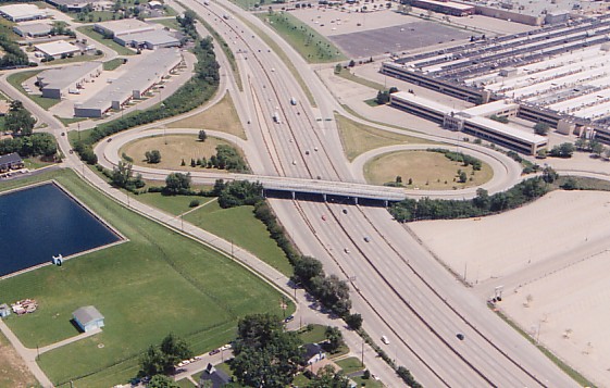
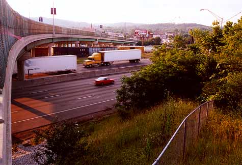
The overpass in this photo was built as part of the
1970's
reconstruction, and mainly serves
the parking lot at bottom right. Notice that cars
headed
to I-75 southbound must first head
north on the feeder road at right, cross the overpass,
and the loop back around south.
(Larry Stulz
photo)
The 1970's also saw the designation of I-75 through
Northern
Kentucky as I-71/75, to coincide with the opening of the neighboring
expressway.
Fort Washington Way was designated as I-71, meaning that the new
expressway
used the Fort Washington Way/I-75 interchange built in 1963 for its
north
interchange. Miles and interchanges were numbered along the shared
I-71/75
stretch according to I-75's original numbering. This stretch is always
referred to as "I-75" by locals, and many are probably unaware that it
carries
I-71 as well.
1980's
Work began in 1990 on the reconstruction of the
Covington
"Death Hill", which was the most dangerous section of expressway in the
Cincinnati area. Spectacular accidents plagued northbound lanes
and southbound traffic was slowed by
trucks. An interchange with Euclid Ave. and Jefferson Ave. in
southern Covington was eliminated.
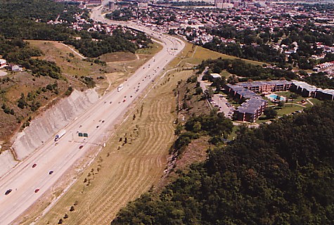
Looking north through the cut, with Covington at top.
Because of the tremendous volume of earth
moved during the project, no trace of the former
S-curve
route through the cut can be seen.
(Larry Stulz
photo)
The rebuilt section descends a 5% grade, with a
single
sweeping turn in place of the previous S-turn and an additional
southbound
climbing lane. Due in part to a labor strike, the project was not
completed
until 1994, but the extreme hassle and expense adequately explained why
the cut was not originally built this way. It also explains
why I-75 was originally planned to cross the Ohio River on a bridge
parallel
to the Southern
Railroad Bridge in Ludlow. In that scenario the descent to
the
bridge would have been much better behaved, with fewer buildings
demolished
in Ludlow than were cleared in Covington.
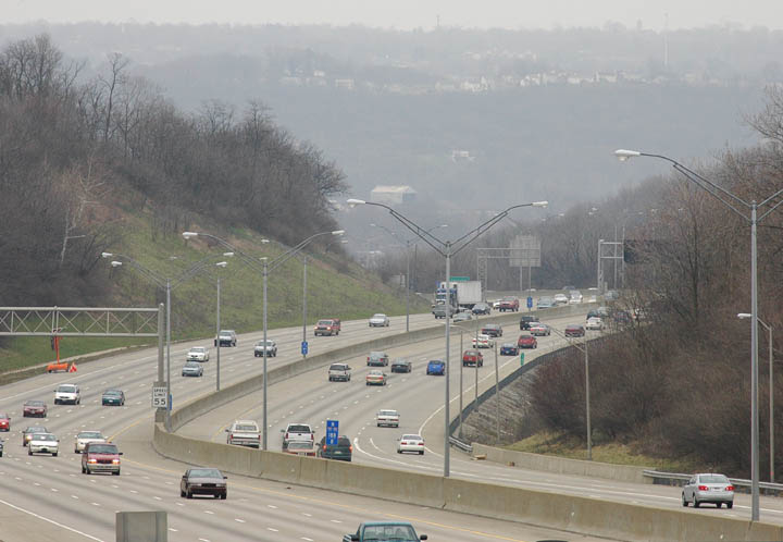
View of I-71/75, just south of the hill.
[March 2005 Jake Mecklenborg]
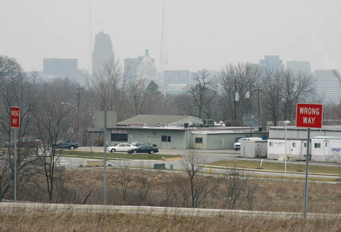
View of the downtown skyline from the Kyle's Lane interchange in
Kentucky.
[March 2005 Jake Mecklenborg]
The full 2,000 mile route of I-75 between Ontario
and
Miami, FL was completed in 1986. Stretches between downtown and the
I-74
interchange were resurfaced. I-71/75 in Kentucky was widened to eight,
and even ten lanes in some sections. The elaborate Florence Mall (Exit
183) interchange opened in the late 80's.
1990's
The surly Ludlow
Viaduct (1914) was dismantled in 1990 and replaced with a new
generic overpass. This was not the only area landmark to be
demolished
early in the decade -- the Camp Washington Workhouse, located about a
mile
south of the viaduct, was demolished as well. The fortress-like
Workhouse,
built in the 1860's, was easily the most frightening building in the
city
and still housed prisoners in archaic conditions until the new downtown
jail opened in the 1980's. Also removed in the 1990's were the
flamboyant neon Western-Southern Life Insurance sign and the the silo
painted
like a Pabst Blue
Ribbon beer can.
A recent view of the new Ludlow Viaduct
[Summer 2000 Jake Mecklenborg]
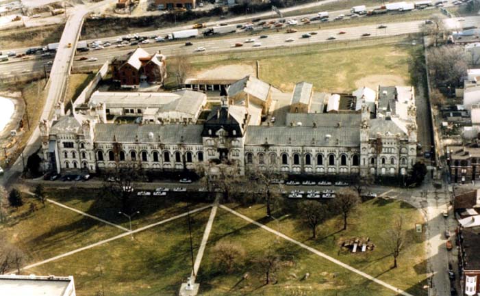
An undated photo of the Camp Washington Workhouse,
with
I-75 at top.
The Cross
County Highway interchange (Exit 10) opened in 1991, serving the
newly
completed eastern half of the highway. In 1994, the western half of the
interchange opened along with the short Cross County Highway segment up
the hill to Galbraith Rd. in Finneytown. This stretch was part of
the original Wright-Lockland Highway, and the reconstruction removed
all
traces of its original appearance.
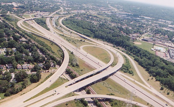
The new Cross County Highway interchange --
despite the
miles of ramps
involved in the interchange,
there is no ramp from south I-75 to either Cross
County
east or west, meaning driver
must exit at Galbraith Rd. and then find one of
the
local
Cross County entrance ramps.
[Larry Stulz
photo]
Another major project in the 1990's was the the Ft.
Wright
(mile 189) curve reconstruction. This curve was the tightest along the
entire 2,000 mile length of I-75.
The Union Center Boulevard interchange at mile 19
opened
in 1998. This interchange was built by private developers who bought
hundreds
of acres of farm land to either side of the expressway. In the few
short
years since its opening, dozens of large warehouses and manufacturing
plants
have been built in the area. They have been accompanied by
the usual array fast food restaurants, gas stations, and motels.
The overpass itself has a strange "UC" logo repeated several times
across
it, and is often confused for "University of Cincinnati" when in fact
it
stands for "Union Center".
1. 1940's
2. 1950's
3. 1960's
4. 1970's-1990's
5. Recent
News and Future Plans
Back to
Cincinnati-transit.net