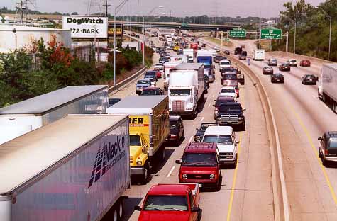
I-75 is the oldest, busiest, and most interesting expressway in the Cincinnati area. Its 22 years of construction on the Ohio side of the river stretched from 1941 to 1963, with the majority of the roadway built along the route of the old Miami-Erie Canal. The canal and the expressway that replaced it travel parallel to the Mill Creek in an industrial valley that varies in places between one and two miles in width. That the hills bordering the valley resemble those along the Ohio is no coincidence -- the Mill Creek Valley was alternately the prehistoric route of the Ohio and Licking Rivers. With a critical lack of flat land throughout the region, the valley was quickly claimed by industries in the second half of the 19th century. Today the industrial panorama is unbroken for 15 miles, and is the source of I-75's relentless truck traffic, which ranks nearly highest in the nation.
Unlike the urban expressways of Texas, South Florida, Los Angeles, and most younger cities, Cincinnati's hills, erratic street layout, and densely built old neighborhoods prevented I-75 from establishing any sort of pattern with regard to interchanges or the stretches between them. The number of well-behaved interchanges is so short that they both can be listed here: Mitchell Ave. and Glendale-Milford Rd. Every other interchange between the Ohio River and I-275 is irregular in some fashion, involving some combination of short or curved merges, less than seamless integration with pre-existing infrastructure, feeder roads, or left side ramps. This same unpredictability is the story with the roadway itself, as there is no stretch that is both straight and flat measuring longer than 1,000ft. in the 17 miles between the Brent Spence Bridge and I-275, with the exception of the immediate approach to the loop highway.
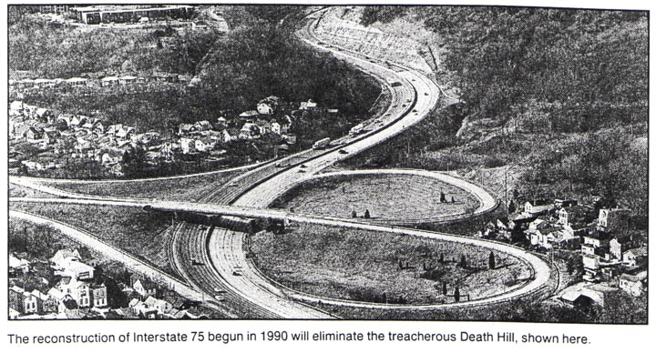
More talked about are the distinctive but notorious segments the expressway, such as the Lockland Split and the above mentioned Brent Spence Bridge. They are dependable sources of aggravation for anyone in a hurry. But the best known individual element is the hill in Covington, where the expressway quickly descends 350 vertical feet from the ridge dividing the Licking River and the Ohio River watersheds. Following the path of Willow Run, a small creek now canalized beneath the roadway, the expressway rounds a bend, enters a broad rock cut, and the Cincinnati business district and Ohio River come suddenly and dramatically into view. Rebuilt in the early 1990's, the hill is now reasonably safe, but its original steeper grade and switchback orientation were the cause of frequent and often fatal accidents for the expressway's first 30 years.
On the Ohio side of the river, the transition from neighborhoods predating the expressway to sprawling postwar suburbs occurs at Glendale-Milford Rd., 15 miles north of downtown. Development initially spread away from I-75 in either direction along I-275 until the 1998 opening of the Union Center Boulevard interchange sparked full-throttle development of over 1,000 acres of Butler County farmland. With the southernmost suburban fringes of Dayton 25 miles north of I-275, and significant development at each of the first three interchanges north of the loop, only ten miles of open countryside and a giant Jesus statue currently separate the two metropolitan regions.
Whereas those heading north on I-75 north from downtown Cincinnati must drive 15 miles before spotting subdivisions and shopping centers built since and because of its construction, one needs only drive four miles south of Cincinnati's downtown business district through Kentucky to see similar suburban development. The transition is abrupt: after a bit more than a mile of 19th century Italianate row houses and traditional city blocks in Covington, drivers are met with 1960's era ranches and 1970's era office buildings at the top of the hill. Relentless 1970's and 1980's suburban development keeps the expressway company for the next ten southward miles, with new housing subdivisions now stretching south of the I-71 split. The only section of 10-lane expressway in the Cincinnati area can be found here, reflecting as much Northern Kentucky's dramatic growth as it does the redundancy of Cincinnati's street and expressway configuration. I-71/75's construction in Kentucky is mostly routine, and along with its typical suburban scenery, is indicative why I-75 through Cincinnati is of exceptional interest.
Now with 60 years of history and a doubling of Cincinnati's metro population in that same time period, the story of I-75's evolution and the growth of the metropolitan area around it is probably more the story than its original construction. Together, construction and its subsequent effects are such a broad topic that I could not hope to give a comprehensive account without months of research and writing.
It is now anticipated that major reconstruction of
nearly all of I-75 in Cincinnati will commence in or soon after
2012. This project will replace or augment the Brent Spence
Bridge with a parallel
span, and increase capacity north to I-275 as well as improve safety
throughout.
I have organized the I-75 article into chronological sections because of the large amount of photographs and information.
1. 1940's
2. 1950's
3. 1960's
4. 1970's-1990's
5. Recent
News and Future Plans